Tampilkan postingan dengan label walking. Tampilkan semua postingan
Sabtu, 15 September 2012
adventures
,
excursions
,
family fun
,
heritage building
,
hikes
,
historic buildings
,
historic sites
,
mountain sports
,
nature
,
road trips
,
travel
,
walking
Tidak ada komentar
MY CARIBOO ROAD TRIP: PART 3
WHERE IN THE WORLD IS WELLS?
I have heard of the town called "Wells" for many years and always wondered where it was and who lived there. On my road trip to Barkerville, after the shuttle driver picked me up at Quesnel that Saturday morning, he said we would be making a brief stop at Wells to pick up other passengers. I would finally have an opportunity to see just where in the world Wells was and what this tiny town nestled 1200 meters up in the mountains had that might attract people to live there.

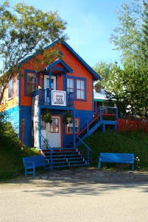
Back in the 1930's Wells was a company townsite for the Cariboo Gold Quartz Mine. Its close proximity to the gold rush town of Barkerville made it a stop-over place for travelers to the area. The town is unique with its wooden-framed heritage buildings that are painted bright colors. It has become a favorite residence for writers and artists and is the home of the Island Mountain Arts School and Public Gallery.

The narrow main street that looks like a set from a western movie is lined with coffee shops and art galleries. The town has a theatre group that provides most of the actors for the interactive shows at Barkerville during the summer months, and there are various music events. That weekend there was a Cowboy Jamboree dance in Wells, in conjunction with the Cowboy Jamboree weekend at Barkerville.


We only stopped long enough for me to take a few photographs but it piqued my interest enough that I wouldn't mind exploring it at another time. There are hotels, motels, B&Bs and campground for travelers so it's a perfect stopping-off place for anyone going to Barkerville or other places in that area.

The Williams Creek Nature Trail is near the town. Wells has many well maintained hiking and biking trails and in winter opportunities for snowmobiling, cross-country skiing and dog sledding. There are guided tours offered in the community and also equipment rentals.
I would have liked to explore more of this quaint little town but it was time to board the shuttle again and head farther up into the mountains to my destination: Barkerville, the town established and made famous during the Cariboo Gold Rush.

NEXT: MY CARIBOO ROAD TRIP: PART FOUR: The Rollicking Town of Barkerville
I have heard of the town called "Wells" for many years and always wondered where it was and who lived there. On my road trip to Barkerville, after the shuttle driver picked me up at Quesnel that Saturday morning, he said we would be making a brief stop at Wells to pick up other passengers. I would finally have an opportunity to see just where in the world Wells was and what this tiny town nestled 1200 meters up in the mountains had that might attract people to live there.

Back in the 1930's Wells was a company townsite for the Cariboo Gold Quartz Mine. Its close proximity to the gold rush town of Barkerville made it a stop-over place for travelers to the area. The town is unique with its wooden-framed heritage buildings that are painted bright colors. It has become a favorite residence for writers and artists and is the home of the Island Mountain Arts School and Public Gallery.

The narrow main street that looks like a set from a western movie is lined with coffee shops and art galleries. The town has a theatre group that provides most of the actors for the interactive shows at Barkerville during the summer months, and there are various music events. That weekend there was a Cowboy Jamboree dance in Wells, in conjunction with the Cowboy Jamboree weekend at Barkerville.


We only stopped long enough for me to take a few photographs but it piqued my interest enough that I wouldn't mind exploring it at another time. There are hotels, motels, B&Bs and campground for travelers so it's a perfect stopping-off place for anyone going to Barkerville or other places in that area.

The Williams Creek Nature Trail is near the town. Wells has many well maintained hiking and biking trails and in winter opportunities for snowmobiling, cross-country skiing and dog sledding. There are guided tours offered in the community and also equipment rentals.
I would have liked to explore more of this quaint little town but it was time to board the shuttle again and head farther up into the mountains to my destination: Barkerville, the town established and made famous during the Cariboo Gold Rush.

The road to Barkerville
Senin, 25 April 2011
WALKS WITH RUTHAKI #3: A Sunday Walk in Stanley Park

Lost Lagoon Fountain, Stanley Park
?
There's nothing nicer on a mild Sunday than a long walk in Stanley Park. Last week I didn't participate in the annual Vancouver Sun "Fun Run", instead I went on a marathon walk of my own through the quiet paths and around the lagoon at Stanley Park. It turned into a longer walk than anticipated because the bus routes were blocked off due to the Fun Run, but I wandered down from Robson and Denman Street to the edge of the Lagoon and set off from there.
There were lots of birds in the lagoon this day. It must have been the Blue Heron's nesting time as I saw an unusual number of them by the shore, as well as the usual gaggles of geese, ducks and swans.

Instead of taking the seawall walk, this time I cut through the Park via the road and walking under the big trees, stopping now and then to enjoy the views of English Bay and the Burrard Inlet. My destination was the Ferguson Point Tea House as I had discovered a forgotten voucher for a meal that I had and wanted to use it before it expired. As I learned later, I could have easily reached the Tea House by the seawall, but the stroll through the forested part of the park was a nice change.
 Ferguson Point was originally the site of an army a garrison and the Tea House was once a mess for officers stationed there during World War II. Later it was used as a residence for the military, until the 1950's and opened as the Ferguson Point Tea Room in 1978.
It's a pleasant place to go for brunch, afternoon tea, or late lunches with a beautiful view of the Inlet from the windows. It's a cozy atmosphere, and the day I was there the tables and couches were occupied by a lot of family groups. I enjoyed a meal of fish and chips and a refreshing margarita.

After my lunch I walked back along the seawall. There were lots of walkers, joggers, cyclists and in-line skaters out that day enjoying the fresh air and sunshing. The seawall is always one of my favorite places for a good long walk with stops now and then on the benches to enjoy the views and meditate.

Third Beach
I walked along as far as Second Beach and cut back through by the Lagoon Path into the Park itself where the Spring flowers are in bloom. There were cherry blossoms and the flower beds were bright with daffodils, hyacinths and other spring blooms. I enjoy strolling the gardens in the Park and walked through back to the bus loop just behind the Malkin Bowl tea house/restaurant.

?

Rabu, 23 Maret 2011
cycling
,
in-line skating
,
jogging
,
parks
,
picnics
,
springtime
,
walking
,
walks
Tidak ada komentar
WALKS WITH RUTHAKI #1: WALK, JOG, CYCLE, SKATE: The Stanley Park Seawall
Last weekend I went on my first long sea-wall walk in Stanley Park. It doesn�t matter what kind of weather, you�ll always find walkers, joggers, cyclists and in-line skaters on seawall. It was the first spring-like weekend of the year and a good day for a brisk tour around one of Vancouver's most popular walks.

I started my walk from the Park entrance, walking along by the Yacht Club, going east toward Brockton Point.
The Stanley Park seawall is 8.8 kms (5.5 mi) so I don't usually attempt the whole circuit. People have been enjoying this seaside path since 1917 but it wasn�t until the mid �70�s when the walk was properly surfaced making it an easier route for walkers, joggers and cyclists. The seawall loop around Stanley Park is one of Vancouver�s most popular locations to enjoy the outdoors. The path is divided making it easier and safer for pedestrians and those on wheels. Remember to check the park map for signs indication direction as cyclists can only go in a counter-clockwise direction.
There are interesting sights along the way and benches lining the path if you need to pause for a rest. You might also consider a horse-drawn carriage ride around the Park which is loads of fun. You can also rent bikes.
 Be sure and stop to see the totem poles at the Brockton Point Oval. And past that is the famous 9-o'clock gun that booms out over Coal Harbour to mark the time every night. There's also the historic Dead Man's Island, now the naval reserve, but once a First Nations burial ground. Next you'll come to the Brockton Point Lighthouse. In the early settlement days, there was a small village near here where ship-jumpers lived with their native wives.
This part of the walk will take you all the way around to Lumberman�s Arch. This was once the site of a First Nations village. There's a children's water-park here and even though there wasn't water to frolic in, there were plenty of kids enjoying fun on the adventure equipment there.
From here you can cut back through the park to the entrance. There are refreshment stands at Brockton Point, Lumberman�s Arch, and by the Aquarium if you want to take a coffee or snack break. You'll also find washroom facilities there.
I stopped on the beach here for my first picnic of the season and rested awhile enjoying the view of the snow-capped mountains of North Vancouver and the busy waterway of Burrard Inlet and the inner harbour.

From here I walked back through the park on a quest to find cherry blossoms, but because of the late season there weren't any in bloom around the Japanese memorial for WWI. I stopped at the Aquarium to view the Belugas in their outdoor pool. Then I walked along the trails to the Pavilion and bus depot.
On my next Sunday sea-wall walk I'll take a different route. There's lots to see in the Park and it makes for a relaxing, refreshing afternoon to enjoy the day on the sea-wall.
Bike and Rollerblade rentals are located near Denman and Georgia St.
Stanley Park Cycle: 768 Denman St. 604-688-0087
Stanley Park Rentals: 1798 W. Georgia St. 604-688-5141
For a map of the seawall: http://vancouver.ca/parks/parks/stanley

I started my walk from the Park entrance, walking along by the Yacht Club, going east toward Brockton Point.
The Stanley Park seawall is 8.8 kms (5.5 mi) so I don't usually attempt the whole circuit. People have been enjoying this seaside path since 1917 but it wasn�t until the mid �70�s when the walk was properly surfaced making it an easier route for walkers, joggers and cyclists. The seawall loop around Stanley Park is one of Vancouver�s most popular locations to enjoy the outdoors. The path is divided making it easier and safer for pedestrians and those on wheels. Remember to check the park map for signs indication direction as cyclists can only go in a counter-clockwise direction.
There are interesting sights along the way and benches lining the path if you need to pause for a rest. You might also consider a horse-drawn carriage ride around the Park which is loads of fun. You can also rent bikes.

This part of the walk will take you all the way around to Lumberman�s Arch. This was once the site of a First Nations village. There's a children's water-park here and even though there wasn't water to frolic in, there were plenty of kids enjoying fun on the adventure equipment there.
From here you can cut back through the park to the entrance. There are refreshment stands at Brockton Point, Lumberman�s Arch, and by the Aquarium if you want to take a coffee or snack break. You'll also find washroom facilities there.
I stopped on the beach here for my first picnic of the season and rested awhile enjoying the view of the snow-capped mountains of North Vancouver and the busy waterway of Burrard Inlet and the inner harbour.

From here I walked back through the park on a quest to find cherry blossoms, but because of the late season there weren't any in bloom around the Japanese memorial for WWI. I stopped at the Aquarium to view the Belugas in their outdoor pool. Then I walked along the trails to the Pavilion and bus depot.
On my next Sunday sea-wall walk I'll take a different route. There's lots to see in the Park and it makes for a relaxing, refreshing afternoon to enjoy the day on the sea-wall.
Bike and Rollerblade rentals are located near Denman and Georgia St.
Stanley Park Cycle: 768 Denman St. 604-688-0087
Stanley Park Rentals: 1798 W. Georgia St. 604-688-5141
For a map of the seawall: http://vancouver.ca/parks/parks/stanley
Langganan:
Postingan
(
Atom
)