Tampilkan postingan dengan label nature. Tampilkan semua postingan
Minggu, 03 Januari 2016
archaeology
,
architecture
,
beaches
,
cathedrals
,
holidays
,
monuments
,
musuem
,
nature
,
photography; exhibits
,
snowboard
Tidak ada komentar
TOURING AROUND TORREVIEJA


My travel writer friend Inka invited me to visit her in Spain last September. She lives in Torrvieja, a lovely seaside city on the Costa Blanca. The name of the town comes from the original ancient guard tower (Torre Vieja meaning Old Tower) which once guarded the harbour. Torrevieja was originally a salt-mining and fishing village, located between two large salt lakes, one blue/green, the other pink, caused by the pigments and algae of the salty environment. The lakes are now an official nature reserve attracting a wide variety of bird life. The main attraction are the flamingos. Up to 2000 can be seen there during breeding season. Did you know that the flamingos turn bright pink from eating the shrimp from the salty water? The salt lake at La Mata lagoon produces pyramids of salt most of which is exported abroad.
During the 19th century, salt was shipped from Torrevieja. Salt and fishing are the major industries.
Today Torrevieja is a popular resort for holidayers from England, France, Germany and Russia. A lot of Brits have retirement homes here.
Inka and I had fun exploring the sights. On my first day there we met up with our friend Darlene Foster, a Vancouver travel writer who lives nearby. We spent an excellent day touring the pirate's island of Tabarca, a short boat trip from Torrevieja. (see my previous blog).
The city itself has various interesting historical sites which we explored including the two main churches - the Hermitage (new) and the Virgin of Cenception (old).
The next day we got the bus to CARTEGENA, an old historical city famous from the Punic Wars. This is where Hannibal set off with is elephants on his journey to Rome.
Cartagena has been inhabited for over two millennia, founded in 227 BC by the Carthaginians. During the Roman Empire it was known as Carthago Nova (the New Carthage) and was one of the most important cities of the time because of its defensive port, one of the most important sea ports in the western Mediterranean. The city is now a major destination for cruise ships.


Remains of the Punic Walls


Roman Theatre

Roman Villa

There are many things to see in Cartegena including 12 museums, several noteworthy churches and monuments as well as the archaeological sites. We walked along the Calle Mayor and admired the many beautiful art deco houses then relaxed at a cafe bar.


A Delicious Lunch
The following day we took a bus to a small city nearby, Santa Palo. We walked through the town to see the old church and the 16th century castle. Unfortunately all the museums were closed. I'd have liked to see the Salt Museum but I did see the salt lakes and piles of salt heaped nearby.

16th century Castle


Seaside View
Our pleasant outing concluded with a nice lunch in a good restaurant (chorizo flambe in rum and potatoes with ali olli - garlic sauce).
It was a pleasant visit with my friend and I appreciated seeing all the sights of these interesting old cities.
The next day I took the bus to Murcia and from there, another relaxing bus journey to Malaga where I'll stay a few days visiting my friends Carlos and Natalia.
Sabtu, 15 September 2012
adventures
,
excursions
,
family fun
,
heritage building
,
hikes
,
historic buildings
,
historic sites
,
mountain sports
,
nature
,
road trips
,
travel
,
walking
Tidak ada komentar
MY CARIBOO ROAD TRIP: PART 3
WHERE IN THE WORLD IS WELLS?
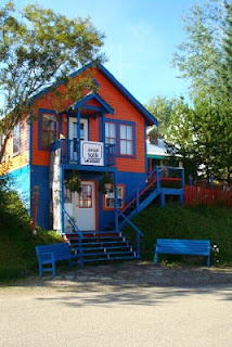
I have heard of the town called "Wells" for many years and always wondered where it was and who lived there. On my road trip to Barkerville, after the shuttle driver picked me up at Quesnel that Saturday morning, he said we would be making a brief stop at Wells to pick up other passengers. I would finally have an opportunity to see just where in the world Wells was and what this tiny town nestled 1200 meters up in the mountains had that might attract people to live there.

Back in the 1930's Wells was a company townsite for the Cariboo Gold Quartz Mine. Its close proximity to the gold rush town of Barkerville made it a stop-over place for travelers to the area. The town is unique with its wooden-framed heritage buildings that are painted bright colors. It has become a favorite residence for writers and artists and is the home of the Island Mountain Arts School and Public Gallery.

The narrow main street that looks like a set from a western movie is lined with coffee shops and art galleries. The town has a theatre group that provides most of the actors for the interactive shows at Barkerville during the summer months, and there are various music events. That weekend there was a Cowboy Jamboree dance in Wells, in conjunction with the Cowboy Jamboree weekend at Barkerville.


We only stopped long enough for me to take a few photographs but it piqued my interest enough that I wouldn't mind exploring it at another time. There are hotels, motels, B&Bs and campground for travelers so it's a perfect stopping-off place for anyone going to Barkerville or other places in that area.

The Williams Creek Nature Trail is near the town. Wells has many well maintained hiking and biking trails and in winter opportunities for snowmobiling, cross-country skiing and dog sledding. There are guided tours offered in the community and also equipment rentals.
I would have liked to explore more of this quaint little town but it was time to board the shuttle again and head farther up into the mountains to my destination: Barkerville, the town established and made famous during the Cariboo Gold Rush.

NEXT: MY CARIBOO ROAD TRIP: PART FOUR: The Rollicking Town of Barkerville
I have heard of the town called "Wells" for many years and always wondered where it was and who lived there. On my road trip to Barkerville, after the shuttle driver picked me up at Quesnel that Saturday morning, he said we would be making a brief stop at Wells to pick up other passengers. I would finally have an opportunity to see just where in the world Wells was and what this tiny town nestled 1200 meters up in the mountains had that might attract people to live there.

Back in the 1930's Wells was a company townsite for the Cariboo Gold Quartz Mine. Its close proximity to the gold rush town of Barkerville made it a stop-over place for travelers to the area. The town is unique with its wooden-framed heritage buildings that are painted bright colors. It has become a favorite residence for writers and artists and is the home of the Island Mountain Arts School and Public Gallery.

The narrow main street that looks like a set from a western movie is lined with coffee shops and art galleries. The town has a theatre group that provides most of the actors for the interactive shows at Barkerville during the summer months, and there are various music events. That weekend there was a Cowboy Jamboree dance in Wells, in conjunction with the Cowboy Jamboree weekend at Barkerville.


We only stopped long enough for me to take a few photographs but it piqued my interest enough that I wouldn't mind exploring it at another time. There are hotels, motels, B&Bs and campground for travelers so it's a perfect stopping-off place for anyone going to Barkerville or other places in that area.

The Williams Creek Nature Trail is near the town. Wells has many well maintained hiking and biking trails and in winter opportunities for snowmobiling, cross-country skiing and dog sledding. There are guided tours offered in the community and also equipment rentals.
I would have liked to explore more of this quaint little town but it was time to board the shuttle again and head farther up into the mountains to my destination: Barkerville, the town established and made famous during the Cariboo Gold Rush.

The road to Barkerville
Kamis, 13 September 2012
aboriginal
,
adventure
,
bus
,
First Nations
,
fishermen
,
historic sites
,
mountains
,
nature
,
tours
Tidak ada komentar
MY CARIBOO ROAD TRIP: Part One
NORTH TO THE KLONDIKE GOLD FIELDS: HOPE AND BEYOND
For years I've been wanting to visit the old gold rush town of Barkerville in British Columbia's Cariboo district and finally this year I managed to accomplish this. It's a long trip by bus, 10 hours from Vancouver, but the journey was well worth it, through some of the west coast's most spectacular scenery.
 The first brief stop along the way was the town of Hope. (The sign itself captured my attention!) Hope is the entryway to the Fraser Canyon where the mighty Fraser and Coquihalla rivers join. The town is nestled in the mountain pass of the Cascade and Coast Mountains.
 Heading north, we soon pass the famous "Hells Gate", located immediately downstream of Boston Bar in the Fraser Canyon. Here the towering rock faces of the Fraser River plunge toward each other creating rapids. From here you can go on river rafting excursion through this narrow passage of roiling water.


This has also been a popular fishing ground for the local aboriginal communities and in the past, European settlers also congregated there to fish for salmon. It was on this route that the gold rush miners traversed up the river to the Cariboo gold fields.

 This is also the canyon area where the first explorers came paddling down the river or portaging to the Coast. The scenery is spectacular, still as wild as it was then when later men trudged north in search of gold.

North, toward the village of Cache Creek, there were the remains of forest fires that had ravaged the countryside in recent years.

Cache Creek is located at the junction of the Trans Canada Highway and Highway 97 on the Thompson Plateau, junction of the Cariboo and Thompson Valleys. There are rolling grasslands and hills covered in sagebrush and cactus with a backdrop of beautiful mountains.

 Cache Creek was the halfway point for prospectors en route to the Cariboo Gold Fields. Here (above) you'll see a way-marker pointing in the directions of the many places these hopeful miners came from. Many were from California, others from England, Scotland, Ireland and other European countries. Today travelers like myself who are following the historical gold rush trail still stop off at Cache Creek.

All along the route are pristine lakes. The little town of Lac La Hache is renowned for excellent fishing. The lake is a popular for swimming, boating, parasailing, water skiing and camping. Even in the winter there are activities such as ice fishing, cross country skiing and skating. I was most impressed by Lac La Hache. For many years I knew the name but this was the first time I'd visited there.

Next stop is the rustic village of 100 Mile (also known as "Hundred Mile House") located on a plateau where there are numerous lakes. The area is excellent for swimming, fishing, bird watching and horse-back riding. For thousands of years the Chilcotin First Nations lived, hunted and traded here and still claim the region as their traditional territory. In the mid 1800's miners flocked to the area folling the news of gold in the Cariboo. A wagon road was built to manage the traffic that came up from Lilloet on the Fraser River north to Barkerville. At the time, this was known as Bridge Creek House and was renamed 100 Mile House because it was 100 miles from Lilloet (Mile 0). Between 1862 and 1870 there were more than 100,000 travelers through this region. Eventually a freight and stagecoach line carried people and provision to the gold fields, cattle were imported and a thriving ranching culture developed. By the 1900's logging and forestry became the dominant economic source. Today tourism, logging and ranching are the leading industries in the South Cariboo.

After Lac la Hache, passing through 100 Mile, there is another spectacular lake known as Dragon Lake. At the north end of this lake is Williams Lake, a small town in the central Cariboo. They are famous for the Williams Lake Stampeded. The town is named in honour of Secwepemc chief William who was instrumental in counselling the Shuswap band from joining the Chilcotin in their uprising against the new settlers back in the 1860's during the Cariboo Gold Rush.
This entire area is so rich with history, that for a history-buff like me it was a treasure trove of stories, added to the magnificent scenery. It was easy to imagine being one of those early settlers, the men trudging north to the gold fields, or the brave explorers who came down the river to the west coast.
The Cariboo Gold Rush attracted a rush of American prospectors to the Fraser Canyon in 1858 Many stayed on as permanent settlers. Others began to explore the rest of the province searching for new finds. It was after Billy Barker, a miner from England, struck pay-dirt north in Barkerville, that floods of men arrived from other parts of the world seeking their fortune in the gold fields around Quesnel. The area became known as "the Cariboo", NOT "Caribou", which is an Algonquin word "xalibu" meaning "a pawer or scracher'. In BC it is regarded as a corruption of the French word "Cariboeu or Cerboeuf" meaning "reindeer" as it is a favorite haunt of that species.
After ten enjoyable hours on the Greyhound bus, by 6.30 pm that evening I arrived at the town of Quesnel where the next phase of my Cariboo adventure began.
NEXT: Part II. Quesnel and beyond.
For years I've been wanting to visit the old gold rush town of Barkerville in British Columbia's Cariboo district and finally this year I managed to accomplish this. It's a long trip by bus, 10 hours from Vancouver, but the journey was well worth it, through some of the west coast's most spectacular scenery.


This has also been a popular fishing ground for the local aboriginal communities and in the past, European settlers also congregated there to fish for salmon. It was on this route that the gold rush miners traversed up the river to the Cariboo gold fields.


North, toward the village of Cache Creek, there were the remains of forest fires that had ravaged the countryside in recent years.

Cache Creek is located at the junction of the Trans Canada Highway and Highway 97 on the Thompson Plateau, junction of the Cariboo and Thompson Valleys. There are rolling grasslands and hills covered in sagebrush and cactus with a backdrop of beautiful mountains.


All along the route are pristine lakes. The little town of Lac La Hache is renowned for excellent fishing. The lake is a popular for swimming, boating, parasailing, water skiing and camping. Even in the winter there are activities such as ice fishing, cross country skiing and skating. I was most impressed by Lac La Hache. For many years I knew the name but this was the first time I'd visited there.

Next stop is the rustic village of 100 Mile (also known as "Hundred Mile House") located on a plateau where there are numerous lakes. The area is excellent for swimming, fishing, bird watching and horse-back riding. For thousands of years the Chilcotin First Nations lived, hunted and traded here and still claim the region as their traditional territory. In the mid 1800's miners flocked to the area folling the news of gold in the Cariboo. A wagon road was built to manage the traffic that came up from Lilloet on the Fraser River north to Barkerville. At the time, this was known as Bridge Creek House and was renamed 100 Mile House because it was 100 miles from Lilloet (Mile 0). Between 1862 and 1870 there were more than 100,000 travelers through this region. Eventually a freight and stagecoach line carried people and provision to the gold fields, cattle were imported and a thriving ranching culture developed. By the 1900's logging and forestry became the dominant economic source. Today tourism, logging and ranching are the leading industries in the South Cariboo.

After Lac la Hache, passing through 100 Mile, there is another spectacular lake known as Dragon Lake. At the north end of this lake is Williams Lake, a small town in the central Cariboo. They are famous for the Williams Lake Stampeded. The town is named in honour of Secwepemc chief William who was instrumental in counselling the Shuswap band from joining the Chilcotin in their uprising against the new settlers back in the 1860's during the Cariboo Gold Rush.
This entire area is so rich with history, that for a history-buff like me it was a treasure trove of stories, added to the magnificent scenery. It was easy to imagine being one of those early settlers, the men trudging north to the gold fields, or the brave explorers who came down the river to the west coast.
The Cariboo Gold Rush attracted a rush of American prospectors to the Fraser Canyon in 1858 Many stayed on as permanent settlers. Others began to explore the rest of the province searching for new finds. It was after Billy Barker, a miner from England, struck pay-dirt north in Barkerville, that floods of men arrived from other parts of the world seeking their fortune in the gold fields around Quesnel. The area became known as "the Cariboo", NOT "Caribou", which is an Algonquin word "xalibu" meaning "a pawer or scracher'. In BC it is regarded as a corruption of the French word "Cariboeu or Cerboeuf" meaning "reindeer" as it is a favorite haunt of that species.
After ten enjoyable hours on the Greyhound bus, by 6.30 pm that evening I arrived at the town of Quesnel where the next phase of my Cariboo adventure began.
NEXT: Part II. Quesnel and beyond.
Langganan:
Postingan
(
Atom
)