Tampilkan postingan dengan label fishermen. Tampilkan semua postingan
Senin, 08 April 2013
artifacts
,
boat
,
boat building
,
culture
,
family fun
,
fishermen
,
heritage
,
historical sites
,
Japanese
,
museums
,
park
,
tradition
Tidak ada komentar
A VISIT TO NIKKEI PLACE AND MUSEUM

It's taken me a long time to make a point to visit the National Nikkei Museum and Heritage Centre. I used to post regular program notices for them when I wrote for Planet Eye Traveler (The Vancouver Guide) but as many times as I'd intended to take in some of their exhibits or just pass by to say hello, I didn't get around to it.

Last week, however, I needed to stop in to pick up a gift packet for the BC Travel Writer's gala in May. Once I got there, I was more than sorry I'd neglected to go sooner.
The multi-use facility houses the National Nikkei Heritage Centre and the Japanese Canadian National Museum. It's located at the corner of Sperling and Kingsway and easy to reach by public transit if you don't have a car.
The Centre promotes understanding and appreciation of the Japanese Canadian culture and heritage and the contribution of Japanese Canadians to our Canadian society. They offer many programs and special events including art exhibits, a speaker's series, bazaars and many other problems both for youth and elders included. There's art classes, folk dance workshops, exercise groups such as yoga, flower arranging and even a course in the traditional incense ceremony.

When I arrived at the Centre I was first impressed by the lovely gardens that surround the building. The cherry blossoms were all in bloom which seemed appropriate. The building itself is impressive and much larger than I'd expected.


I only stayed a short while and mainly visited the museum on the ground floor where there is an exhibit of Ryoshi: Nikkei fishing on the BC Coast. (It runs until May 19,2013). The admission is by donation. It displays the fisherman's life from the bustling docks of Steveston to the remote inlets on the northern Coast. For many years Japanese Canadians have made a unique contribution to fishing in BC both before and after the war.


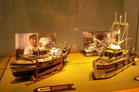
Upstairs in the museum there is an exhibit of Taiken: Japanese Canadians Since 1877. It's an ongoing exhibit so I'll have to go back and take a look. It deals with the first arrivals of Nissei in 1877 and the hardships of the early pioneers and struggles during the war years when the Japanese of the Coast were interned and their properties confiscated.


Don't pass up this interesting Museum and Cultural Centre. It's open every day but Monday.
Check their website for more information on programs and exhibits.
www.nikkeiplace.org

Kamis, 13 September 2012
aboriginal
,
adventure
,
bus
,
First Nations
,
fishermen
,
historic sites
,
mountains
,
nature
,
tours
Tidak ada komentar
MY CARIBOO ROAD TRIP: Part One
NORTH TO THE KLONDIKE GOLD FIELDS: HOPE AND BEYOND
For years I've been wanting to visit the old gold rush town of Barkerville in British Columbia's Cariboo district and finally this year I managed to accomplish this. It's a long trip by bus, 10 hours from Vancouver, but the journey was well worth it, through some of the west coast's most spectacular scenery.
 The first brief stop along the way was the town of Hope. (The sign itself captured my attention!) Hope is the entryway to the Fraser Canyon where the mighty Fraser and Coquihalla rivers join. The town is nestled in the mountain pass of the Cascade and Coast Mountains.
 Heading north, we soon pass the famous "Hells Gate", located immediately downstream of Boston Bar in the Fraser Canyon. Here the towering rock faces of the Fraser River plunge toward each other creating rapids. From here you can go on river rafting excursion through this narrow passage of roiling water.


This has also been a popular fishing ground for the local aboriginal communities and in the past, European settlers also congregated there to fish for salmon. It was on this route that the gold rush miners traversed up the river to the Cariboo gold fields.

 This is also the canyon area where the first explorers came paddling down the river or portaging to the Coast. The scenery is spectacular, still as wild as it was then when later men trudged north in search of gold.

North, toward the village of Cache Creek, there were the remains of forest fires that had ravaged the countryside in recent years.

Cache Creek is located at the junction of the Trans Canada Highway and Highway 97 on the Thompson Plateau, junction of the Cariboo and Thompson Valleys. There are rolling grasslands and hills covered in sagebrush and cactus with a backdrop of beautiful mountains.

 Cache Creek was the halfway point for prospectors en route to the Cariboo Gold Fields. Here (above) you'll see a way-marker pointing in the directions of the many places these hopeful miners came from. Many were from California, others from England, Scotland, Ireland and other European countries. Today travelers like myself who are following the historical gold rush trail still stop off at Cache Creek.

All along the route are pristine lakes. The little town of Lac La Hache is renowned for excellent fishing. The lake is a popular for swimming, boating, parasailing, water skiing and camping. Even in the winter there are activities such as ice fishing, cross country skiing and skating. I was most impressed by Lac La Hache. For many years I knew the name but this was the first time I'd visited there.

Next stop is the rustic village of 100 Mile (also known as "Hundred Mile House") located on a plateau where there are numerous lakes. The area is excellent for swimming, fishing, bird watching and horse-back riding. For thousands of years the Chilcotin First Nations lived, hunted and traded here and still claim the region as their traditional territory. In the mid 1800's miners flocked to the area folling the news of gold in the Cariboo. A wagon road was built to manage the traffic that came up from Lilloet on the Fraser River north to Barkerville. At the time, this was known as Bridge Creek House and was renamed 100 Mile House because it was 100 miles from Lilloet (Mile 0). Between 1862 and 1870 there were more than 100,000 travelers through this region. Eventually a freight and stagecoach line carried people and provision to the gold fields, cattle were imported and a thriving ranching culture developed. By the 1900's logging and forestry became the dominant economic source. Today tourism, logging and ranching are the leading industries in the South Cariboo.

After Lac la Hache, passing through 100 Mile, there is another spectacular lake known as Dragon Lake. At the north end of this lake is Williams Lake, a small town in the central Cariboo. They are famous for the Williams Lake Stampeded. The town is named in honour of Secwepemc chief William who was instrumental in counselling the Shuswap band from joining the Chilcotin in their uprising against the new settlers back in the 1860's during the Cariboo Gold Rush.
This entire area is so rich with history, that for a history-buff like me it was a treasure trove of stories, added to the magnificent scenery. It was easy to imagine being one of those early settlers, the men trudging north to the gold fields, or the brave explorers who came down the river to the west coast.
The Cariboo Gold Rush attracted a rush of American prospectors to the Fraser Canyon in 1858 Many stayed on as permanent settlers. Others began to explore the rest of the province searching for new finds. It was after Billy Barker, a miner from England, struck pay-dirt north in Barkerville, that floods of men arrived from other parts of the world seeking their fortune in the gold fields around Quesnel. The area became known as "the Cariboo", NOT "Caribou", which is an Algonquin word "xalibu" meaning "a pawer or scracher'. In BC it is regarded as a corruption of the French word "Cariboeu or Cerboeuf" meaning "reindeer" as it is a favorite haunt of that species.
After ten enjoyable hours on the Greyhound bus, by 6.30 pm that evening I arrived at the town of Quesnel where the next phase of my Cariboo adventure began.
NEXT: Part II. Quesnel and beyond.
For years I've been wanting to visit the old gold rush town of Barkerville in British Columbia's Cariboo district and finally this year I managed to accomplish this. It's a long trip by bus, 10 hours from Vancouver, but the journey was well worth it, through some of the west coast's most spectacular scenery.


This has also been a popular fishing ground for the local aboriginal communities and in the past, European settlers also congregated there to fish for salmon. It was on this route that the gold rush miners traversed up the river to the Cariboo gold fields.


North, toward the village of Cache Creek, there were the remains of forest fires that had ravaged the countryside in recent years.

Cache Creek is located at the junction of the Trans Canada Highway and Highway 97 on the Thompson Plateau, junction of the Cariboo and Thompson Valleys. There are rolling grasslands and hills covered in sagebrush and cactus with a backdrop of beautiful mountains.


All along the route are pristine lakes. The little town of Lac La Hache is renowned for excellent fishing. The lake is a popular for swimming, boating, parasailing, water skiing and camping. Even in the winter there are activities such as ice fishing, cross country skiing and skating. I was most impressed by Lac La Hache. For many years I knew the name but this was the first time I'd visited there.

Next stop is the rustic village of 100 Mile (also known as "Hundred Mile House") located on a plateau where there are numerous lakes. The area is excellent for swimming, fishing, bird watching and horse-back riding. For thousands of years the Chilcotin First Nations lived, hunted and traded here and still claim the region as their traditional territory. In the mid 1800's miners flocked to the area folling the news of gold in the Cariboo. A wagon road was built to manage the traffic that came up from Lilloet on the Fraser River north to Barkerville. At the time, this was known as Bridge Creek House and was renamed 100 Mile House because it was 100 miles from Lilloet (Mile 0). Between 1862 and 1870 there were more than 100,000 travelers through this region. Eventually a freight and stagecoach line carried people and provision to the gold fields, cattle were imported and a thriving ranching culture developed. By the 1900's logging and forestry became the dominant economic source. Today tourism, logging and ranching are the leading industries in the South Cariboo.

After Lac la Hache, passing through 100 Mile, there is another spectacular lake known as Dragon Lake. At the north end of this lake is Williams Lake, a small town in the central Cariboo. They are famous for the Williams Lake Stampeded. The town is named in honour of Secwepemc chief William who was instrumental in counselling the Shuswap band from joining the Chilcotin in their uprising against the new settlers back in the 1860's during the Cariboo Gold Rush.
This entire area is so rich with history, that for a history-buff like me it was a treasure trove of stories, added to the magnificent scenery. It was easy to imagine being one of those early settlers, the men trudging north to the gold fields, or the brave explorers who came down the river to the west coast.
The Cariboo Gold Rush attracted a rush of American prospectors to the Fraser Canyon in 1858 Many stayed on as permanent settlers. Others began to explore the rest of the province searching for new finds. It was after Billy Barker, a miner from England, struck pay-dirt north in Barkerville, that floods of men arrived from other parts of the world seeking their fortune in the gold fields around Quesnel. The area became known as "the Cariboo", NOT "Caribou", which is an Algonquin word "xalibu" meaning "a pawer or scracher'. In BC it is regarded as a corruption of the French word "Cariboeu or Cerboeuf" meaning "reindeer" as it is a favorite haunt of that species.
After ten enjoyable hours on the Greyhound bus, by 6.30 pm that evening I arrived at the town of Quesnel where the next phase of my Cariboo adventure began.
NEXT: Part II. Quesnel and beyond.
Kamis, 08 September 2011
A DAY WALKING STEVESTON'S HISTORICAL WATERFRONT

Steveston Village, located on the southwestern shore of Richmond, was once a frontier seaport and principal port on the mighty Fraser River. It was founded by William Herbert Steves in 1880. He imagined it would be a town that would rival Vancouver. The town flourished up to 1910 and then there was a decline in the salmon industry. At the turn of the twentieth century the village was one of the busiest fishing ports in the world. There were fifteen salmon canneries, six hotels, numerous saloons and gambling dens and daily windjammers anchored in the port loading canned salmon to distribute to the world markets. On weekends, up to 10,000 people thronged Steveston's boardwalks: sailors from all over the world, Native Indians, Japanese, Chinese and European immigrants. In 1918 a devastating fire destroyed much of the town and there was more hardship during the 1930`s depression.

Bunkhouse kitchen

At the time the Second World War broke out there were many Japanese fishermen living here and after Pearl Harbour their boats and property were seized as they were all sent away to interment and Steveston lost half its population and many businesses. There is a small memorial park for the Japanese fishermen at Garry Point and one of the historic houses left at Steveston belonged to a Japanese family.

It's always a pleasant outing to spend the day at Steveston. You can rent bikes to ride along the dikes, visit the fish market on the wharf, or the Farmer's Market. Or just stroll along the boardwalk and take in all the sights while you investigate the heritage buildings, some now turned into museums.

Kite flying at Garry Point
Last weekend my friends and went to Steveston, first for a salmon barbecue at my friend Diane's home. She bought the fish fresh from the fish market on Steveston's wharf. Then we set off for a tour, to show my friend from Germany around. Patrick has been to Vancouver many times, but never to Steveston.
By the Steveston boat works
We started off at one end of the boardwalk where there are several heritage houses including one of the bunkhouses used for workers in the cannery. The day was hot and so walking along by the river was refreshing. When we got to Steveston town there are many boutiques and excellent dock-side restaurants: everything from seafood to Italian food. One of the most popular (on the wharf) is Pajo`s Fish and Chips. The town itself has many heritage buildings including the Steveston Museum which shows the history of the community. (pick up a brochure that will guide you through a Steveston Village Heritage Walking tour).

Fisherman`s Wharf
The Fisherman`s Wharf was bustling with activity as the fish boats were in port displaying their catch and lots of people go there to buy their fresh salmon, shell fish and even sea urchins. 
Sea Urchins

Fresh Salmon for Sale

Sculpture of Salmon Cannery Workers.
The day proved to be invigorating and somewhat tiring by the time we walked all the way back to where the car was parked. But if you take the bus there, or drive, you can park in the village and walk from there. I also recommend renting bikes down on the wharf and cycling the dikes. If you cycle east you`ll reach the historic London Heritage Farm or going around Garry Point you can cycle as far as the airport.

Fishermen`s Memorial at Garry Point

Patrick and I with a view of the River from Garry Point
Langganan:
Postingan
(
Atom
)